![]()
![]()
![]()
![]()

|
|
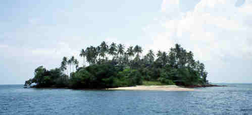
From Nongsa, we entered Selat Riau (Riau Straight). This is a busy shipping channel for traffic from Jakarta to Singapore along with all of the local traffic. It took us about 24 hours to traverse, mostly because the Capt'n was adamant that with the wind at a sailable angle, we would not use the engine. This meant a long night (Dave D's first) tacking up a narrow channel dodging freighters, tankers and tugs with barges. Great sail though. Once we cleared the channel, the seas picked up some chop and what wind there was came straight on the nose. On went the iron top-sail and off we bounced in to the chop. We approached the equator about mid day on the morning of the 22nd of September. In looking for a place to anchor, we entered the Lingga Island group. The first bay that we went through was like something out of the computer game Myst. Everywhere in the bay were houses up on stilts with nets hanging between the poles. There was no one in sight. Everywhere we looked we could see houses, but no people. Very spooky. We weaved our way through the houses toward the southern opening. This was about 2 miles north of the equator. and we were determined to anchor on the equator. We checked the charts and found what looked like the perfect spot. Located about 50 feet south of the equator was a very pretty little island. The perfect spot to set up a cruisers bar for all of those thirsty sailors heading north for Singapore.
The problem is the island has a pretty good fringing reef. The only spot where we could get close enough was just off this beach, but there, it dropped off very quickly to 14 meters. If we put out enough scope for 14 meters, we would swing onto the reef if the wind changed. So as pretty as it was, we decided to move a little further west and anchor in the lee of Palau Berang. Another nice sandy bottom, but this time only 7 meters deep. Palau Berang is less than ½ mile south of the equator and provided very good shelter from the prevailing Easterlies. Dave and Dave rowed ashore and explored the island and reported back that there were no dancing girls. The next morning, we hoisted anchor and entered the town of Sembanka for fuel. Sembanka is a typical Indonesian fishing village with the houses built on stilts over the water. The fuel barge was located across the channel from the town and seemed like the busiest spot. We rafted up to a fishing boat that was taking on fuel and with a bunch of hand waving and sniffing of jerry cans, managed to get across that we wanted diesel (known locally as solar). I know that we were taken advantage of on the price. We paid US$0.11 per liter. The going rate should have been US$0.09, but then, this turned out to be the cheapest we paid the whole trip for fuel delivered to the boat. From Sembanka, we were off to Belitung, also known as Billington Island.
|
Send email to
tkohrs@dragonstoy.com with
questions or comments about this web site.
|