![]()
![]()
![]()
![]()

|
|
Out of Gladstone I sailed down to Pancake Creek behind Bustard head. This is a very shallow creek that is a popular anchorage for boats making the passage either north or south. It is a very pretty place but even at high tide I could not find a channel to get into the inner anchorage. With the wind from the SE it did not matter though.
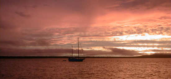
Pancake creek sunset. The water in the foreground is only 1/2 meter deep. You can see the sand bar just in front of the mountain. From Pancake Creek I sailed down to Port Bundaberg for another night. I can't say much about the area as I arrived after dark and left at sunrise. The people at the marina were very friendly though. The next stop after Bundaberg was Urangan at the head waters of Hervey (pronounced Harvey) Bay. Hervey Bay is a large bay open to the north formed by Fraiser Island (the worlds largest sand island) and the Breaksea Spit. With the SE trades blowing this are offers calm water of not a break from the wind.
When the Met office finally started to lift the high wind warnings, I made my plans to move on. The route out is through the Great Sandy Straight. This is a long narrow straight behind Frasier Island. At the south end is Tin Can Bay where I planned to anchor for the night before making the run south to Mooloolaba. This leg of the voyage reinforced to me the old sailor superstition that you should never begin a voyage on a Friday. Friday morning with falling winds, I checked out of the marina and motored over to the fuel dock. Here the first of the misadventures occurred as I took off the wrong fill cap on the deck and put diesel in the holding tank. I only realized my mistake when fuel spilled out on me from the vent. After filling the proper tank, I headed out of the marina. According to the chart, there was a 2 meter deep channel straight out from the marina over to the main channel. It turns out the channel filled in with a passing storm and is now only a 1/2 meter deep., so I got to read a book for 2 hours waiting on the tide. Farther up the channel, I mistook a mangrove for a channel marker and promptly ran aground again. This time I was only stuck for about 20 minutes. I ended the day anchoring out in the middle of Tin Can Inlet in the dark. Not a good anchorage. The next morning things did pick up a bit as I made it over Wide Bay Bar without mishap. From there is was just a matter of fighting the 15 not SE wind to get to Mooloolaba. The wind and seas were a bit higher than expected and I ended up arriving outside the Mooloola river entrance just as dark was setting in. I did manage to find a space at the yacht club for the night, but was thrown out the next day to make room for the Sydney to Mooloolaba racers that were to arrive. In a moment of good luck, I managed to secure the last space in Lawries Marina up the river. But on the way there, the engine died due to water in the fuel from when I transferred the fuel from the holding tank to the main tank. Two hours of pumping cleared the water from the system and the local Coast Guard was kind enough to escort me up the river in case the engine died once more. Never again will I leave port on a Friday.
|
Send email to
tkohrs@dragonstoy.com with
questions or comments about this web site.
|